|
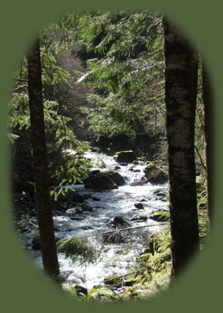
Sharps Creek in the Umpqua River Watershed: The Umpqua, a wild and scenic river, in the High and Old Cascade Mountains of Oregon. Sharps Creek is mining country. Travel down the many side roads along the different creeks, and you'll see claim after claim. In addition to the history of mining in this area, as well as Brice Creek, this area is very beautiful. Just for sightseeing. Sharps creek Recreation Area, of which I hope to have photographs at some point - those I took in March don't seem to me to be worth putting up here, is charming. The rapids pictured to the left, were out and away from the Recreational Area, however. We'd turned to the left, and followed Martin creek, which I must add, is also very beautiful. All the times I'd driven out to Brice Creek, I'd wanted to turn to the right when I saw the sign for Sharps Creek. Finally we did. Boy! I'd been right all along. It's a wonderful area. Plan your visit to the many waterfalls and hiking trails in the Umpqua National Forest. | ||
|
Forward ~ Wildwood Waterfall on beautiful Brice Creek, Back ~ Crescent Lake, a brief detour off the USFS: Umpqua National Forest. Martin Creek in the early light of a late winter morning, a tributary to Sharps Creek to the Row River, to the wild and scenic Umpqua. |
|
||
Campgrounds in the area of Brice Creek, Layng Creek and associated waterfalls:Brice Creek: Cedar Creek Campground, Lund Campground and Hobo Campground. Sharps Creek: Mineral Camp Campground. Sharps Creek Recreation Area, not associated with the Umpqua National Forest, can be found on Sharps Creek also. It has a great swimming hole. Layng Creek: Rujada Campground. Obtain information about these campgrounds on this website, and/or contact the relevant Ranger District with the Umpqua National Forest. Hiking Trails in the Umpqua River watershed in the Umpqua National Forest:Directions for hiking trails to waterfalls and other points of interest in the Row River Watershed of the wild and scenic Umpqua River in the Umpqua National Forest. As well as Directions for the Umpqua River Trail - 12 hiking trails riverside. Directions for hiking trails to the many waterfalls on the wild and scenic Umpqua River off the Rogue Umpqua Scenic Byway. Directions for hiking trails in the south Umpqua watershed. Directions for hiking trails in the Little River watershed. All within the magnificent Umpqua National Forest. Enjoy the North Umpqua Waterfalls Tour on the Rogue Umpqua Scenic Byway:Can include Crater Lake National Park: Introduction. Travel Directions, Map and Scenery ~ can include Crater Lake National Park: Introduction. Experience: splendid scenery, hiking trails for intrepid hikers and those with less enthusiam. Enjoy the magnificent the wild and scenic Umpqua River, Umpqua hot springs near Toketee Campground, rafting on the rapids, hiking the beautiful trail along the Umpqua gorge to magnificent Toketee Waterfalls, my favorite, and the favorite of anyone I've ever spoken to. Hike through a forest garden of dense wild rhododendrons at Warm Spring Waterfalls. Hike the trails to experience the wonder of tumultuous Watson Falls. Don't forget Lemolo Waterfalls and Lemolo Lake. And when you arrive at the north entrance partake the splendor of Crater Lake - Enjoy beauty. Enjoy the Diverse Loop Tour on the Rogue Umpqua Scenic Byway and the Crater Lake Hwy:Includes Crater Lake National Park: Introduction. Travel Directions, Map and Scenery. Experience: splendid scenery, hiking trails for intrepid hikers and those with less enthusiam, experience the majestic Rogue River Gorge at Union Creek and the Natural Bridge, waterfalls, the Rogue River Hiking Trail, hiking trails to Muir Creek Waterfalls and National Creek Waterfalls all in the Rogue - Siskiyou National Forest. Enjoy hiking trails to Mill Creek Waterfalls, Barr Creek Waterfalls and Pearsoney Waterfalls in Prospect, Oregon. Or just stand on the historic Prospect bridge and enjoy the panorama of the Avenue of Giant Boulders. Hike down to the water's edge if you've a mind to. Combine the Umpqua Waterfalls and the Diverse Loop ToursTraveling Oregon on the Rogue Umpqua Scenic Byway and the Crater Lake Hwy: Directions. Travel Oregon and southern California while staying at Gathering Light ... a retreat | |||
|
|
Travel to on the Rogue Umpqua Scenic Byway to Gathering Light ... a retreat: Travel Directions Map and Scenery. Experience the columnar basalt of Toketee Waterfalls, tumultuous Watson Falls ... the wild and scenic Umpqua River in the Umpqua National Forest. Arriving at the north entrance of Crater Lake National Park, enjoy Crater Lake too. Directions to & Day Trips of about 100 miles from the retreat. Little known Scenic Places to explore nature: hiking trails, wetlands, national wildlife refuges, mountains, wilderness areas, river gorges and more near Crater Lake National Park and the retreat: Travel Directions, Map and Scenery. | ||
|
Wood River Wetlands, about ten miles from Gathering Light ... a retreat pictured above. | |||
|
Contact Brad at Gathering Light ... a retreat. | |||