| |
|
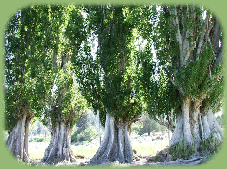
These are old poplars, perhaps planted by the first settlers Oregon Outback Scenic BywayA Path to FollowThe High Desert enfolds, beckoning the explorer, in the beauty that rings across the silence, alight in color that alters in the slightest movement. Delicate changes, shaped in the nuance of movement. Clouds skimming across the sky, sunlight moving across the great of expanse of life lived in the wide open places. While the Oregon Outback is, as they say, out-back, it's easily accessible, and a journey to be accomplished in a day if one wishes. I've done this myself. You can begin at LaPine on Hwy 97, or Lakeview where you'll connect with Hwy 395. For the purposes of our virtual journey, I'll begin with LaPine. If you want to begin at Lakeview, just go backwards. Give yourself a minimum of 4 to 6 hours; this is a 171 - mile trek as measured by the BLM. :-) Plan the time of your visit. Spring and autumn are best. Winter can be beset with snow, and it's pretty dry in the summer with temperatures in the 90s. Stop off points are few and far between, so bring most of what you need. Lakeview is the most comprehensive of "towns" you'll come to on this journey. Most are just little places on the road. Some, like Summer Lake, offer a restaurant. Paisley has a bar if I remember correctly; it probably has food as well. Once you've passed Paisley, forget any idea of stopping for food, drinks or gas until you get to Lakeview. There is a picnicking area in Summer Lake and another closer to Lakeview. The one closer to Lakeview is part of the system of Klamath Basin birding trails. It offers a restroom as well. When we stopped there, it seemed quite a popular place for that purpose. Right now I can't think of the name. Lapine, Oregon: Starting pointLaPine is 30 miles south of Bend. Talk about diversity, LaPine is situated in the Deschutes - Ochoco National Forest. But you'll be leaving that behind as your drive progresses. From LaPine, drive south 3 miles until you see the turnoff for Hwy 31 on the left. Turn, heading south and east. Drive through dense stands of Lodgepole Pine and the beauty of the high desert's evergreen, Ponderosa Pine. About 27 miles east of Oregon Hwy 97, you'll come to our next stop: Fort Rock. Fort RockThe Forest ends abruptly, opening on a vista of vast sagebrush plains. I've heard this area compared to Australia, not so surprising that this area is called the Oregon Outback. Fort Rock, not unlike Australia's Ayer's Rock, seems to emerge from nowhere. While that may be the case, science has dispelled the mystery of seeming incongruence, if not the aura of the same itself. Fort Rock, is the product of a volcanic eruption, not so surprising since Oregon itself has been, and continues to be, composed by violence and cataclysmic eruptions. Not to destroy, but create. But my thoughts wander ... The formation was formed as lava exploded in a giant lake that covered a distance farther than we can see. Originally, the circumference of the rock was complete. It's called a maar composed of volcanic tuff. I'll leave it to you to look that up if you want. Let me just say that I compare it to the Roman coliseum, though the south side has been eroded by the steady lap of the water over the millenia. You can walk up to the base. There are many interesting rock formation, and some lovely wildflowers if you get there at the right time. The wildflowers pictured below were photographed on the trail at the base of the inner circumference of the rock. It was July when they were in bloom. Fort Rock is a mere 7 miles off of Hwy 31. Just follow the signs, and you'll get there. At the park proper, you'll find picnic tables, a restroom, and a plaque that explains much of what I've described here. In addition to this, Fort Rock Homestead Village offers a living history museum, but this is open only during summer. Once you've explored to your heart's content, get back on Hwy 31, heading south to Silver Lake. It was not that far from Fort Rock that native sandals, dated to 9,000 years ago, were discovered in a cave just a few years ago. People have lived in this area for millenia. Want to see pictures of Fort Rock? page 1 and page 2. Silver LakeI used to wonder where the lake was, but then found out that the "lake" is no more than a dry basin that fills with water 30 years or so. The town, one of those places you'll miss if you blink, offers a small general store. A woman used to run a little restaurant there. I don't know if the restaurant is still there and open for business. Get whatever you want, and continue on Hwy 31. From here the road climbs 4,830 feet on Picture Rock Pass. Picture Rock PassPicture Rock Pass is so named because of the ancient native petroglyphs decorating rocks that are within walking distance of the Hwy 31. Leaving this behind, you'll see Summer Lake, a narrow alkaline lake in the desert below. | |
Summer LakeWe first started going to Summer Lake to take advantage of the hot springs. The water from the springs is diverted into a swimming pool, protected from the elements in all types of weather by a barn. A fee is charged. If you are making your journey with an RV and want to explore the area a little, pull in, and camp for the night right there, taking advantage of the nice hot springs as well. Some hot springs are clothing optional. These are not, so bring a swimsuit. Summer Lake is full of surprises. :-) |
|
|
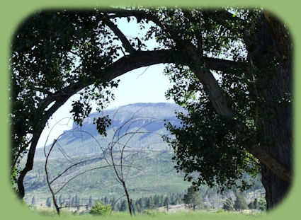
As I stated earlier, Summer Lake has a restaurant, as well as a small general store. In addition, picnicking is offered at a wayside established in honor of the mountain man and explorer, John Fremont (it offers a restroom as well). This is a lovely little spot to stop off for a time, whatever your purpose. Summer Lake, very alkaline, is a haven for birds. Indeed, 18,000 acres has been set aside as the Summer Lake Wildlife Area. It is a breeding, resting and viewing area for terns, gulls, swans and cranes. This is the Pacific Flyway after all. In addition to birds, one can see Big Horn Sheep. I've been told they come down on the slopes of Winter Ridge in February, though I've never been there then. Paisley, OregonPaisley is a bend in the road, literally. :-) As stated above, there is a restaurant/bar, or at least there was the last time we went through. If I remember correctly, it was for sale at that time. I think there's also a sort of hardware store. I guess they have a Mosquito Festival in July. Truth to tell, I've never found the mosquitoes to be bad when I was there, but we're usually only driving through, so I can't say for certain. I do know one can find Chewaucan River there. It's stocked with trout, and if you like to fish, you might have a different story to tell about the mosquitoes. :-) Leaving Paisely, follow Hwy 31 around to Lake Abert. People usually think the name is Albert, but it's not. It's Abert. Lake AbertLake Abert is special. Like Summer Lake, it is alkaline, and a great place for birds. That makes it a good place to be if you're a birder. It boasts one of only a few nesting sites for Snowy Plover in Oregon. During fall migrations the lake hosts thousands of Eared Grebes. Red-necked Phalaropes, Wilson's Phalaropes and more than 1% of the Pacific Flyway's migrating Avocets. * In addition to birds, Lake Abert hosts prehistoric Native American religious art dating as far back as 7999 BCE. Presently, the art: a ceremonial site; rock art, sculptures, carving, is underwater. Like Fort Rock, the geology of Lake Abert and Abert escarpment can be of special interest, depending on one's preferencess. Hwy 31 arrives at at Abert Rim at Valley Falls - I've never seen any falls. Perhaps it's like Klamath Falls, and they're but a memory. Or maybe they're seasonal, I don't know. At any rate, Valley Falls is at the intersection of Hwy 31 with Hwy 395, and that's where you'll find Abert Rim. As stated previously, the poplars pictured above were photographed in Summer Lake, the photo above and to the right is of Winter Ridge at Summer Lake, but if you'd like to see some pictures: page 1 Abert RimAbert Rim, an escarpment, rises 2,000 feet above the desert floor; formed as the crust of the earth faulted. Oregon is dominated by faults, but none displaying the basin and range phenomenom as clearly as this. This one extends 30 miles, and is of special interest to geologists. Like Abert Lake, Abert Rim reflects a desert palette of gentle hues. Leaving Abert Rim behind, drive a mere 27 miles into Lakeview. Lakeview, OregonAs you're heading south into Lakeview, stop and see Old Perpetual, Oregon's only geyser, located a motel/resort 1 mile north of town. Look to the right, and you'll see it set off from the road, looking almost like a fountain, since the feature has not been left in its natural state. But it erupts on a fairly regular schedule of 60 feet every 30 seconds. Lakeview was ":All American City" a few years ago. It boasts at least one gas station, restaurants, at least one park that I've found, a US Bank, a Safeway grocery store, eclectic gift shops and more. In the summer it's a very popular spot for hang gliders. If you like museums, Lakeview has two: Schminck and Lake County Museums. For a bit of nature in town, drive up to Black Cap for a spectacular view of Goose Valley. The Oregon Outback Scenic Byway ends 15 miles south of Lakeview at the border town New Pine Creek and Goose Lake State Recreation Area, a full-service RV park. If you want to find out more contact the Lake County Chamber of Commerce at 541-947-6040. If you want to continue on to Surprise Valley, a wonderful surprise east of California's beautiful Warner Mountain Range. | |
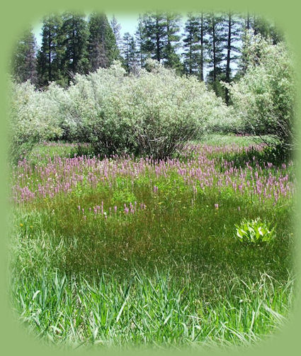
An alternative route out of LakeviewIf you'd rather not go south from Lakeview, head west on Oregon Hwy 140. If you stay on 140, you'll come out on the southern boundary of Klamath Falls, Oregon on Hwy 39. As a diversion to this route, begin on Hwy 140 but then follow the signs for the town of Sprague River. Driving on the Sprague River Hwy, you'll come out on Hwy 97 at Chiloquin. Just a couple of alternatives. If you choose the latter, you'll drive by the sign for Cottonwood Meadows Mountain Lake, a lovely little spot. The wildflowers pictured to the right were photographed in the meadows on our way to Lakeview to take the journey described above. Forward ~ Shasta Trinity Tour Guide. Back ~ Scenery on the Surprise Valley, Warner Mountains "Outback" Tour. USFS: Umpqua National Forest. Places to see on the Oregon Outback Scenic Byway. |
|